Nearmap
 United States
"Property intelligence with certainty"
About
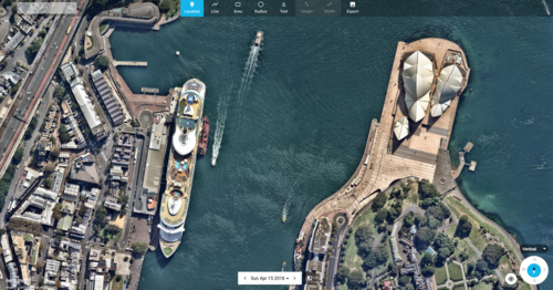
A fleet of custom aircraft flies over neighborhoods to capture high-resolution aerial imagery that updates every few months. This proprietary data covers 95% of the Australian population and 87% of the United States, giving users a fresh view of their surroundings without needing to leave home.
Artificial intelligence processes these raw images to deliver actionable insights for industries ranging from insurance to urban planning. The technology helps insurers assess roof damage after storms, assists city planners in tracking construction progress, and allows emergency managers to evaluate wildfire destruction in places like Spokane or tornado impacts in Menasha.
Nearmap recently launched Nearmap Labs in August 2026 to explore future property intelligence tools while expanding measurement capabilities for P&C insurers. The company also resolved a significant patent dispute with competitor Eagleview in May 2026, securing its intellectual property position through Federal Circuit backing on two out of three challenges.
Products & Sub-brands
Frequently Asked Questions
Who owns Nearmap?
What is Nearmap used for?
Is Nearmap still in business?
How often does Nearmap update its imagery?
Does Nearmap have any competitors?
Keywords
Sources
Company Info
- Headquarters
- Sydney, Australia
- Industry
- Geospatial data, Aerial imagery, Property intelligence
- Australia Coverage
- 95% of population
- US Coverage
- 87% of population
- Patent Dispute Resolution
- Settled with Eagleview (May 2026)
- New Initiative Launch
- Nearmap Labs (August 2026)
Official Website
www.nearmap.com/
Join the community
fans discussing