iFANN
    Search iFANN...
    Log in
    Home
    News
    Videos
    Photos
    GIFs
    Explore
    Polls
    Awards
    iFAMOUS
    Wiki
    Anime
    Rooms
    Notifications
    Messages
    Bookmarks
    Profile
    WikiAwardsiFAMOUSRankingsIndustriesCreator RewardsUser RewardsTermsPrivacyCommunity GuidelinesTakedown / DMCAHelpDevelopers

    © 2026 iFANN

    Home
    Search
    Messages
    Alerts
    Profile
    Photo
    Scarlett S
    Scarlett S@scarlett_s1mo
    🌍United States🌍Puerto Rico💭News
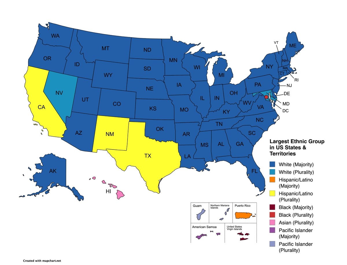
    Largest ethnic group by US state map

    @scarlett_sEvery state and territory, mapped by its biggest ethnic group

    View original post

    Largest ethnic group by US state map

    Photo by @scarlett_s· Sep 26, 2026· United States

    About this photo

    The image is a map of the United States and its territories, color-coded to show the largest ethnic group in each state and territory. The map has a clean, infographic style. A legend on the right explains the color coding for different ethnic groups, including White, Hispanic/Latino, Black, and Asian. The bottom left corner shows smaller maps of Guam, Northern Mariana Islands, Puerto Rico, American Samoa, and the United States Virgin Islands. The text "Created with mapchart.net" is visible at the bottom left.

    See all United States photos

    ?

    No comments yet. Be the first!

    More United States photos

    See all United States photos
    Hatillo Puerto Rico pillar cloudsHatillo Puerto Rico pillar cloudsSpotify Global Top Artists Songs Albums sweepSpotify Global Top Artists Songs Albums sweepHatillo Puerto Rico solar rays illusionHatillo Puerto Rico solar rays illusionTrump Puerto Rico Greenland trade report3Trump Puerto Rico Greenland trade report
    Photo
    Scarlett S
    Scarlett S@scarlett_s1mo
    🌍United States🌍Puerto Rico💭News
    Largest ethnic group by US state map

    @scarlett_sEvery state and territory, mapped by its biggest ethnic group

    View original post

    Largest ethnic group by US state map

    Photo by @scarlett_s· Sep 26, 2026· United States

    About this photo

    The image is a map of the United States and its territories, color-coded to show the largest ethnic group in each state and territory. The map has a clean, infographic style. A legend on the right explains the color coding for different ethnic groups, including White, Hispanic/Latino, Black, and Asian. The bottom left corner shows smaller maps of Guam, Northern Mariana Islands, Puerto Rico, American Samoa, and the United States Virgin Islands. The text "Created with mapchart.net" is visible at the bottom left.

    See all United States photos

    ?

    No comments yet. Be the first!

    More United States photos

    See all United States photos
    Hatillo Puerto Rico pillar cloudsHatillo Puerto Rico pillar cloudsSpotify Global Top Artists Songs Albums sweepSpotify Global Top Artists Songs Albums sweepHatillo Puerto Rico solar rays illusionHatillo Puerto Rico solar rays illusionTrump Puerto Rico Greenland trade report3Trump Puerto Rico Greenland trade report