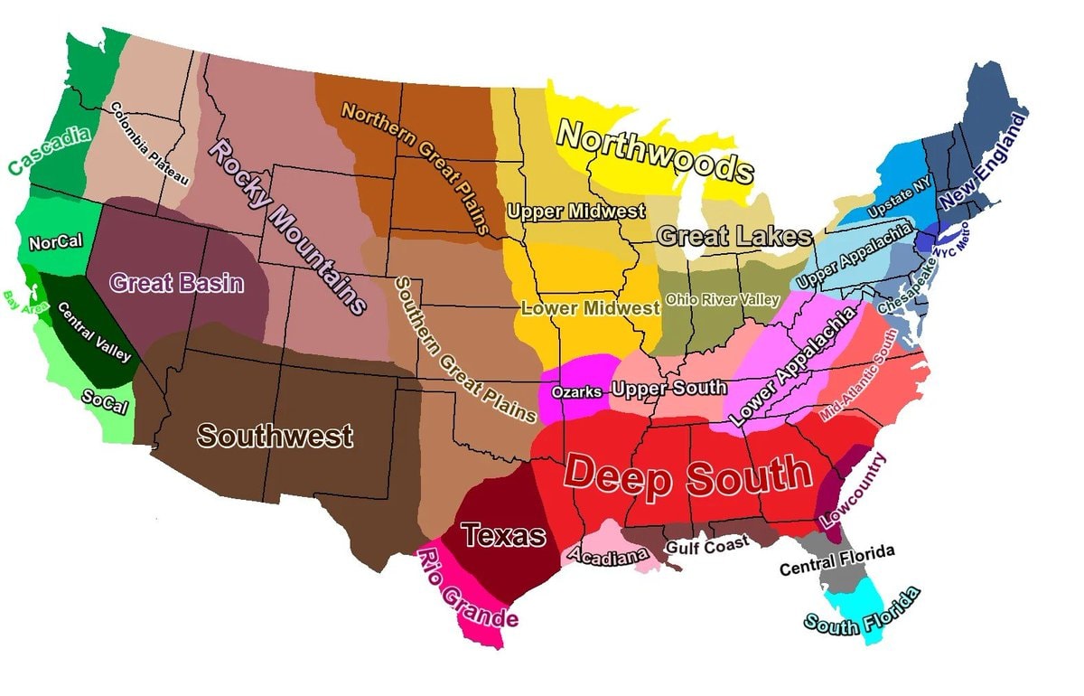
@scarlett_sMapping out the Cultural Regions of the USA
View original post@scarlett_sMapping out the Cultural Regions of the USA
View original postPhoto by @scarlett_s· Aug 26, 2026· United States
The image is a colorful map of the United States divided into various regions. Each region is labeled with text and distinguished by a different color. The style is informational and graphic. The most notable aspect is the distinct color-coding and labeling of regions like "Deep South," "Texas," "Rocky Mountains," and "New England." ON-SCREEN TEXT: Cascadia, Columbia Plateau, NorCal, Great Basin, Central Valley, SoCal, Rocky Mountains, Southern Great Plains, Southwest, Texas, Rio Grande, Deep South, Acadiana, Gulf Coast, Central Florida, South Florida, Northern Great Plains, Northwoods, Upper Midwest, Lower Midwest, Ohio River Valley, Ozarks, Upper South, Lower Appalachia, Mid-Atlantic South, Lowcountry, Great Lakes, Upper Appalachia, Chesapeake, NYC Metro, Upstate NY, New England.
 3New York street scene
 U.S. enforcement of Iranian oil blockade
 Stowe United States autumn
 Ouray United States
 U.S. Senators warn White House on AI cyber threats
 US winters vs Canada's warmest city
 Peacham United States autumn landscape
 Stowe United States
 CDC reports congenital measles cases in US newborns
 US counties without a McDonald's
 2US to vote no on killer robots ban
 Juniper Networks router FAA outage
 US State population under 25 share
 2Backpack crypto exchange logo
 Immigrant population map by state
 2New York Stock Exchange outage
 Tallest men by U.S. state map
 Lisa Google Trends US search map
@scarlett_sMapping out the Cultural Regions of the USA
View original postPhoto by @scarlett_s· Aug 26, 2026· United States
The image is a colorful map of the United States divided into various regions. Each region is labeled with text and distinguished by a different color. The style is informational and graphic. The most notable aspect is the distinct color-coding and labeling of regions like "Deep South," "Texas," "Rocky Mountains," and "New England." ON-SCREEN TEXT: Cascadia, Columbia Plateau, NorCal, Great Basin, Central Valley, SoCal, Rocky Mountains, Southern Great Plains, Southwest, Texas, Rio Grande, Deep South, Acadiana, Gulf Coast, Central Florida, South Florida, Northern Great Plains, Northwoods, Upper Midwest, Lower Midwest, Ohio River Valley, Ozarks, Upper South, Lower Appalachia, Mid-Atlantic South, Lowcountry, Great Lakes, Upper Appalachia, Chesapeake, NYC Metro, Upstate NY, New England.
No comments yet. Be the first!
3New York street sceneU.S. enforcement of Iranian oil blockadeStowe United States autumnOuray United StatesU.S. Senators warn White House on AI cyber threatsUS winters vs Canada's warmest cityPeacham United States autumn landscapeStowe United StatesCDC reports congenital measles cases in US newbornsUS counties without a McDonald's2US to vote no on killer robots banJuniper Networks router FAA outageUS State population under 25 share2Backpack crypto exchange logoImmigrant population map by state2New York Stock Exchange outageTallest men by U.S. state mapLisa Google Trends US search map
No comments yet. Be the first!